Wednesday, September 7, 2011

Jageshwar Temples. Almora. The first Jyotirlinga


JAGESHWAR....THE JYOTIRLINGA

Hidden deep in the Jataganga valley, Jageshwar, one of the 12 Jyotirlingas of Shiva is one of those approachable spots on earth where heaven in all its glory and calm still retains a toe hold on Earth. I accompanied my father three decades back and returned with family and friends twice in the last decade, the most recent in 2008 with Abhimanyu firing the 'Canon'. Thankfully, not much has changed except that the Pujaris this time had cell phones and email addresses! Instant Nirvana can now be home delivered for a consideration, and online at that!!


Most of the 124 large and small stone temples were built from the 7th to 13th century AD by the Ghand dynasty and built/renovated by the Gurjara Pratihara dynasty. The earliest temples were built in the 4th and 5th century AD by the Katyuri kings. The temples include the Dandeshwar Temple, Chandi-ka-Temple, Jageshwar Temple, Kuber Temple, Mritunjaya Temple, Nanda Devi or Nau Durga temple, Nava-grah temple and Surya Temple. The oldest is the Mrityunjaya Temple and the biggest is the ' Dandeshwar Temple'. Jageshwar was once the centre for Lakulish or Nakulish or Pashupat Shaivism that united and revived the various Shaiva sects in the 1st century AD.

A story goes that Shiva appeared at Jageshwar and settled in meditation. The women from the neighboring villages flocked to the place and sat transfixed in prayer. The men were concerned about a Sanyasi attracting their womenfolk. Shiva then assumed a child's form to make the men comfortable. He is worshiped here as a child ever since.

Shiva's love for this place is understandable the moment one turns on the Artola-Jageshwar road that snakes by a small stream through a narrow and lush valley to the spot of the temple complex at the confluence of Nandini and Surabhi, the streams that carry in their clear waters, the nectar of innumerable Himalayan herbs. the whole region is covered with Rhododendron and Oak. People are simple. The air is fresh and calm pervades at all times except when villagers descend from all around for the festivals.


DESTINATION 


  • Lakhudiyar Cave Paintings
  • Jageshwar Group of Temples
  • Vridh Jageshwar


OBJECTIVES

  • Walk the trails through forests of Oak and Rhododendron
  • Sit in calm contemplation/ meditation in the temple, by the stream, under the trees
  • Daily 6pm Arti
  • Jageshwar monsoon festival (Shravan Mela) in Shravan (Approx July15 to Aug 15)
  • Mahashivaratri festival, Shiva's wedding day (Feb 20, 2012. Dates differ each year)
  • Pooram festival at Vadadakkunath temple with all night fireworks and elephant procession
  • Onam (Harvest festival) Aug-Sept


ROUTE AND DISTANCES


View Larger Map
  • Delhi to Almora 278 Km
           Via Moradabad-Rampur-Rudrapur-Kathgodam-Bhimtal-Almora-Artola-Jageshwar
  • Almora to Artola on Almora-Pithoragarh road, 34Km
  • Artola to Jageshwar, Walk, Drive, Share Jeep 4Km

  • Nainital to Jageshwar 100Km
  • Nearest Railhead Kathgodam 135Km from Jageshwar
Rail links with Lucknow, Delhi, Kolkata


Nearest airports Jolly Grant, Dehradun; Pantnagar

ALTITUDES

  • Almora 1638m
  • Binsar 1800-2700m
  • Jageshwar  1870m
  • Vriddh Jageshwar 2200m

OPTIONS IN VICINITY
  • Day Trek to Binsar National Park
  • Short Trek to Vridh Jageshwar 4Km
  • Short Trek to Jakersam temple from Artola
  • Short Trek to Kunjakhali
  • Six Km trek to Dholchina on Almora Sheraghat road
  • Steep six Km from Dholchina to Bineshwar through dense forest
  • 1km from Bineshwar to Binsar

PLACES TO STAY

All Basic

  • KMVN Guest house
  • Forest Rest House
  • Dharamshalas
  • Raj Mahal hotel


ANNOYANCES 
Hardly except the accomodation is basic

Tuesday, August 2, 2011

Phobjikha-Valley of Black Neck Cranes, Bhutan

http://www.yanatravel.com/2008/articles/splendour-of-phobjikha-valley.html

Phobjikha is the valley of the black necked cranes. I wrote this article for the Tashi Delek several years ago and found it once again on the web recently.

Flight to Paro, Bhutan

http://www.yanatravel.com/2008/articles/the-himalayan-flight.html

This is the link of one of my Bhutan articles published in Tashi Delek several years ago, that I found on the web recently, accidentally.The flight from Delhi to Paro via Kathmandu by Druk Air is an experience in itself.

Friday, July 15, 2011

CHOPTA-A Jewel in Garhwal Himalayas, Uttarakhand


It seems like yesterday but it is over twenty years to the day we took an unadvised turn in the road on way to Kedarnath from the Valley of flowers. No one takes this road, we were warned. If stuck, there is no hope for help, food, water, repair. We took the road from Chamoli-Gopeshwat to Ukhimath-Kund. We saw not another soul. Even the road, we got to see only sometimes, but the dense unspoilt forest that accompanied us all the way, was a sight we would give anything for. We came across forests of Deodar, wide undulating meadows and grand views of high snow covered peaks. A lone man reclined on his mud stove under a thatch roof. We were hungry and he had rice and dal and tea. But what was this place and what was he doing here with no people and none seemingly expected. This is Chopta, he said and the trail uphill leads to Tungnath, the highest of the Himalayan shrines and thence to Chandrashila, where Ravana of Lanka meditated for a thousand years to catch a glimpse of Shiva and to seek immortality. I made a mental note. We must come again. We did come again but two decades later. And we are two car loads of family like several others tumbling out of hired Sumos and Innovas. The lonely man spot is now taken by a concrete government house, the road flanked by a dozen food joints, the mud path up is now concrete with mules tethered on either side to ferry pilgrims for a quick darshan. Mercifully, those blinded by faith are few and the route up retains much of its charm.


DESTINATION
  • Chopta
  • Tungnath
  • Chandrashila 


TREK OPTIONS FOR LATER VISIT

  • Deoriyataal
  • Kakragad
  • Madmaheshwar
  • Ansuya Mata
  • Kartik Swamy
  • Vasudhara
  • Kalisila
  • BhavishyaBadri
  • Kalpeshwar
And longer treks to
  • Vasukital
  • Madmaheshwar-Nandikund
  • Rudranath
  • Rudranath-Kalpeshwar
  • Valley of Flowers
(Ignore the language errors and the blog is pretty informative)

OBJECTIVES
  • Walk Chopta
  • Trek Tungnath
  • View sunrise at Chandrashila

After an early start from Haridwar and a breakfast of Mango, Litchi and roasted corn at Rudraprayag we turn to Kund on the road to Kedarnath. I like the GMVN riverside resorts at Chandrapuri and Syalsaur. It is warm in June and not wanting to disturb the sleeping waiters for tea, we drive on. At Agastyamuni we utilise the roadside Sulabh restrooms and drop a five rupee coin in the outstretched palm of the caretaker sleeping away the warm and lazy noontime. Having come so far from Delhi, we expect some respite from the heat. The respite does come but near our destination, with a rapid ascent after Ukhimath. The scene begins to change. Step farms gradually become scarce and so do the homes. AkashKamini, the celestial seductress drops her tresses over the rocks hidden under trees and green foliage at village Pagalpani bridge, about 12km from Ukhimath. Great place to spend a lazy afternoon after paranthas from the dhaba on the riverbank.

Another 12km drive from Akashkamini and we are at Dugalbitta, 6km short of Chopta. There is the PWD rest house with a great view over the valley. The space opposite is occupied by roadside shacks, the dhabas and a hundred meter descent to the unimaginatively built Mayadeep hotel. I found the half a dozen Alpine resort tents in the adjoining meadow, much more pleasant at Rs.1500 a day for a couple without meals. We stayed the first day at Magpie resort, 200 meters short of Dugalbitta and an equal distance walk/climb through near virgin forest opening to one of the most breathtaking meadow-forest-mountain-peaks combination I have ever imagined. The row of half a dozen differently colored tents and an open air bamboo roof dining space at the opposite edge of the meadow, with a backdrop of forest and snow capped peaks, is as close to a poet's heaven as it can possibly be. 

Tungnath is a short 3.5km walk, but steep. It is a surprisingly clean path considering the general Indian indifference to littering. Perhaps we are changing! Tea shops on the way are a refreshing respite to complaining legs. The temple at Tungnath looks ready to crumble any moment. No sign of any significant repair work having come its way after the damage in the last great Chamoli quake of 1999. The way rain falls in the sanctum, the rocks in the roof could be porous like a sieve. We found a Rs.400 room for two in the temple guest house, the best in town, but with plumbing that either leaks or goes totally dry. Beds were fine, at least not stinking like the quilts in Ganesh guest house opposite the temple entrance where the rest of the family retired at Rs.300 a night for four people.

Soaked by the afternoon rain and without any change of clothes, the night was not one of our best. It didn't rankle though, because we slept just a few hours, getting up at 3AM to begin ascent to Chandrashila at 3.30. We took an hour and a half, walking slowly on aching limbs uphill, guided by the boy from Ganesh hotel. Was it eerie or was it divine but this is one of the most memorable walks of my life, with lovely meadows, steep paths, slippery stones, passing through mist and rising above the clouds, all within those 1.5km walked in darkness lighted by the brightest stars I ever imagined. The peaks of Chaukhamba, Nanda Devi, Trishul and Kedar floated like ancient galleons over the ocean of clouds complete with waves. It was pure luck that the clouds were low and the horizon above was clear like nothing, not even air existed. We watched the sunrise, unlike any I have seen before. Then came the moment when the light of the rising sun split like laser rays reaching for the far corners of the Lord's domain to announce the beginning of a new day.

Time to return. All the way down to Chopta. With lungs breathing easy the way down looked different from the way up. We noticed flowers, Oaks and pines. We noticed meadows and boulders. We were singing and taking more pictures. We were already planning the next visit.........in winter! 


ROUTE AND DISTANCES
  • Delhi to Haridwar (220 km)
  • Haridwar to Rudraprayag (87 km)
  • Rudraprayag to Kund(On Kedarnath road)( 32 km)
  • Kund to Dugalbitta(Via Ukhimath) (28 km)
  • Dugalbitta to Chopta ( 5km)
  • Chopta to Tungnath(walk) (3.5km)
  • Tungnath to Chandrashila(walk) (1.5km)


CHOPTA IS MIDWAY ON THE ROAD FROM UKHIMATH TO CHAMOLI

 
ALTITUDES
  • Haridwar (240 m)
  • Devprayag (475 m)
  • Srinagar Garhwal (579 m)
  • Rudraprayag (1000 m)
  • Ukhimath (1319 M)
  • Chopta (2600 m)
  • Tungnath (3680 m)
  • Chandrashila (3962 m)

 
EXPERIENCES
  • Har Ki Pauri Ganga arti at sunset
  • River rafting on Ganga, Shivpuri
  • Tea at river side Chandrapuri or Syalsaur
  • Lunch at Pighla Pani on river Akash Kamini 10 km from Ukhimath
  • Explore Dugalbitta
  • Tungnath trek
  • Chandrashila sunrise 

ANNOYANCES
Traffic jams at Muzaffarnagar, Roorkie, Haridwar, Rishikesh
Dirty beds and quilts at Tungnath

PLACES TO STAY

GMVN Ukhimath, PWD Rest house Duggalbitta, Mayadeep Dugalbitta, Alpine resort Dugalbitta.
Of course when I go I will call Bharat(09758667755). The location of Magpie camp resort would be as much a reason as the destination itself.

SEASON TO GO

Different seasons different moods. Go when you wish.  


                                                               PHOTOS


    Thursday, June 30, 2011

    Harsil - Paradise on the Bhagirathi, Gangotri


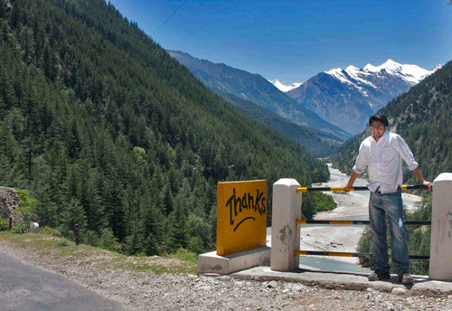
    The month of May burns hot in the plains of India's North. So we head further North into the cooler high Himalayas. Abhimanyu and I tossed a couple of backpacks into the trusted old Suzuki Vitatra. Mom threw in some packed lunch and fruit and off we were on a journey of treks and explorations around the hamlet of Harsil in Uttarakhand. Little did we know that the journey would be made memorable by some unexpected events. Having started from Gurgaon early, we were already beyond Rishikesh by the time I normally stumble to the dining table for breakfast. The drive through Narendra Nagar, Chamba and New Tehri was smooth. A.R Rehman had been singing his 'Salaam' to mother India for the umpteenth time when we ground to a halt at the end of an endless queue of traffic trying to approach a single petrol station outside Uttarkashi. If it had been only for the petrol station, it would still be fine but that was not to be. We moved slower than a snail, covering barely a kilometer in over an hour. Our plans of hitting Harsil by late afternoon went for a toss. Darkness had shrouded everything by the time we finally covered the 3 Kms length of Uttarkashi, one inch at a time. Now we were desperate for a place to hit the bed as much out of exhaustion as out of the fear of driving over a curve and into the depths of the mighty Bhagirathi.


    The next morning , after a breakfast of allu paranthas we started the short drive to Harsil, enjoying the company of the rocks, river, forest and meadows. A kilometer beyond Harsil and an equal distance before Dharali we found a beautifully situated 'Springdales' overlooking the Bhagirathi where it spreads and slows down for a breather in its run from the glacier to plains in the North. Here we made our camp in a first floor room.


    DESTINATION
    • HARSIL
    • GANGOTRI

    OBJECTIVES
    • Trek to Sat Tal
    • Walk to Mukhba
    • Experience Harsil and the Tibetan village of Bagori
    • Join Clean Gangotri action campaign
    The SAT TAL trek starts amongst the ferns behind the Springdales and also from several points on the Harsil to Dharali road. It is steep, or so it feels to our unaccustomed oxygen starved lungs. Sweating and panting, we climb past an apple orchard over the mud path wet by the light drizzle. A forest of tall Deodars shades us from rain. An hour later, we have passed by the last of the tall trees. Fallen logs herald the beginning of a green meadow and the first of the seven pools that the Pandavas stopped by. The five brothers seem to have preceded us to every heavenly place on the subcontinent that we have ever touched!! Another climb and we are at the floating meadow. The grass grows on little deceptive floating mud islands that could give way under foot. Horses and cows are said to sink in the grass regularly. No wonder there is a Tantric baba's hut next to the mystery meadow. He lives there with his consort, an appretice Sadhu and a motley crowd of skulls, bones, honey bees, scorpions and an occasional cobra. The Baba was out on his annual pilgrim trail. The junior Sadhu explained to us the tantric practices in a slow monotone chatter designed to delay our departure. Of course he was pretty lonely at the top!
    Beyond the floating meadow and more pools at higher levels, we entered the dense shrubs of rhododendron with not a path in sight. We had to create our own way, slipping on wet soil and rocks, hanging by the branches, ducking under foliage, wet from rain and sweating inside. The promise of the mountain top view and a glacier in its crevasse prodded us till the bushes became too dense, the slope too steep and the fear of a sleeping bear too intense. If rising up in the thicket was tough, descending was tougher. We slipped, got pricked by thorns and impaled on dry branches but high on adrenaline we barely felt anything. Next time we shall carry a sickle, a rope and a big stick but we shall do this again....soon!!

    MUKHBA is the village up the ridge on the other side of the river from Dharali. This is the winter abode of the Goddess Ganga from the temple at Gangotri. A village of stone and rock huts with old grannys in doorways, children playing in streets and women working on woodfires in their kitchen. I found the men at the village grocery cum tea shop outside the Ganga temple watching a cricket match in the grey stone courtyard. Walk across the ridge to arrive at Harsil. Descend through the military camp to the Harsil market.

    HARSIL is a fairytale village across the bridge from the highway. This is also a military garrison so watch out lest you tresspass. The once quiet market place now buzzes with Tata sumos reversing into each other, trying to enter or exit the space they share with shoppers and travellers. A narrow street winds without logic to the GMVN rest house, descending to the river across the hotel lobby and dining hall. The main village road climbs up beyond the market to a fork. The right is military zone. The left reaches the 'Wilson Cottage' of the Raja Wilson, the 1857 British Army deserter, entrepreneur, timber merchant, mercenary who even minted his own coins! The original cottage turned to ashes in a fire, a poor replica is now a government house. Beyond Wilson cottage cross the bridge on the stream to romantic meadows and apple trees. The stream branches out into narrow rivulets dividing the meadow into green islands covered with soft moss. The valley descends from a distant mountain in a massive cascade of rocks, logs and rivulets ending with a reunited rocky stream gushing to the Bhagirathi below. A second bridge takes us across the Bhottiya and Tibetan village of Bagori.

    THINGS TO PACK(CHECKLIST)
    • Money
    • Walking Shoes
    • Raincoat and Umbrella
    • Camera, Battery, Charger, Adapter
    • Spare shoes
    • First aid box
    • Flashlight
    • Warm jacket, wind cheater, thermals

    ROUTE AND DISTANCES
    • Delhi to Rishikesh(227 km)
    • Rishikesh to Uttarkashi(71 km)
    • Uttarkashi to Harsil(72 km)
    • Harsil to Gangotri(18 km)
    ALTITUDES
    • Rishikesh - 356 m
    • Uttarkashi- 1158 m
    • Harsil- 2620 m
    • Gangotri- 3048 m
    • Gaumukh- 4350 m


    View Larger Map

    EXPERIENCES
    • Evening arti at Har Ki Pauri, Haridwar
    • Evening arti at Sivananda ashram, Rishikesh
    • Engage and photograph Rajasthani pilgrims enroute Gangotri
    • At Uttarkashi traffic jam, lecture pilgrims against littering banana peels and plastic bags
    • Mingle with locals at Mukhba and Bagori
    • Discuss the supernatural with the Tantric baba at Sattal amongst scorpions at his hut
    • Join Bhagirathi Vahini 'Clean Ganga' initiative at Gangotri

    PLACES TO STAY
    Hotel Springdales is beautifully located midway between Harsil and Dharali (1km from each), overlooking the Bhagirathi at its loveliest stretch. Basic rooms. Good food particularly if you take charge of the kitchen with some tips thrown around. First floor has good views and less disturbance from stragglers racing to catch sleeping space as darkness sets in the valleys. Opposite it is the Shiv Den which is a cheaper second option!
    GMVN tourist bungalow, Harsil is at a lovely location approached from the Harsil village market. The Bhagirathi flows literally in its backyard. However it lacks in any mesmerising views from the rooms which were damp when we visited. The dining hall too is, less talked about the better.
    Leisure hotels has expensive but basic tents in an apple orchard on the river bank in Dharali. No river view from the tents. No direct path to the river that flows a few meters away. Walk a hundred meters to reach the river from across the orchard.
    Several small hotels and room rentals exist in both Harsil and Dharali.

    ANNOYANCES
    Traffic jams
    Garbage/polythene/bottles. When shall we learn???
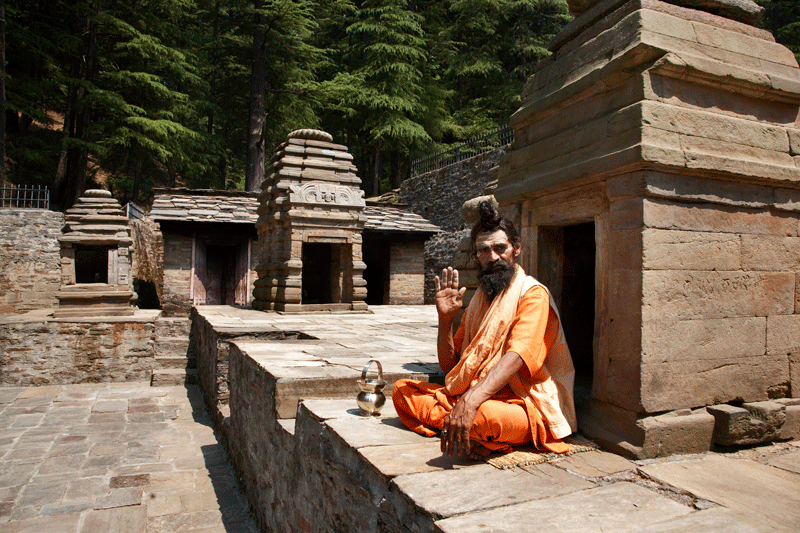